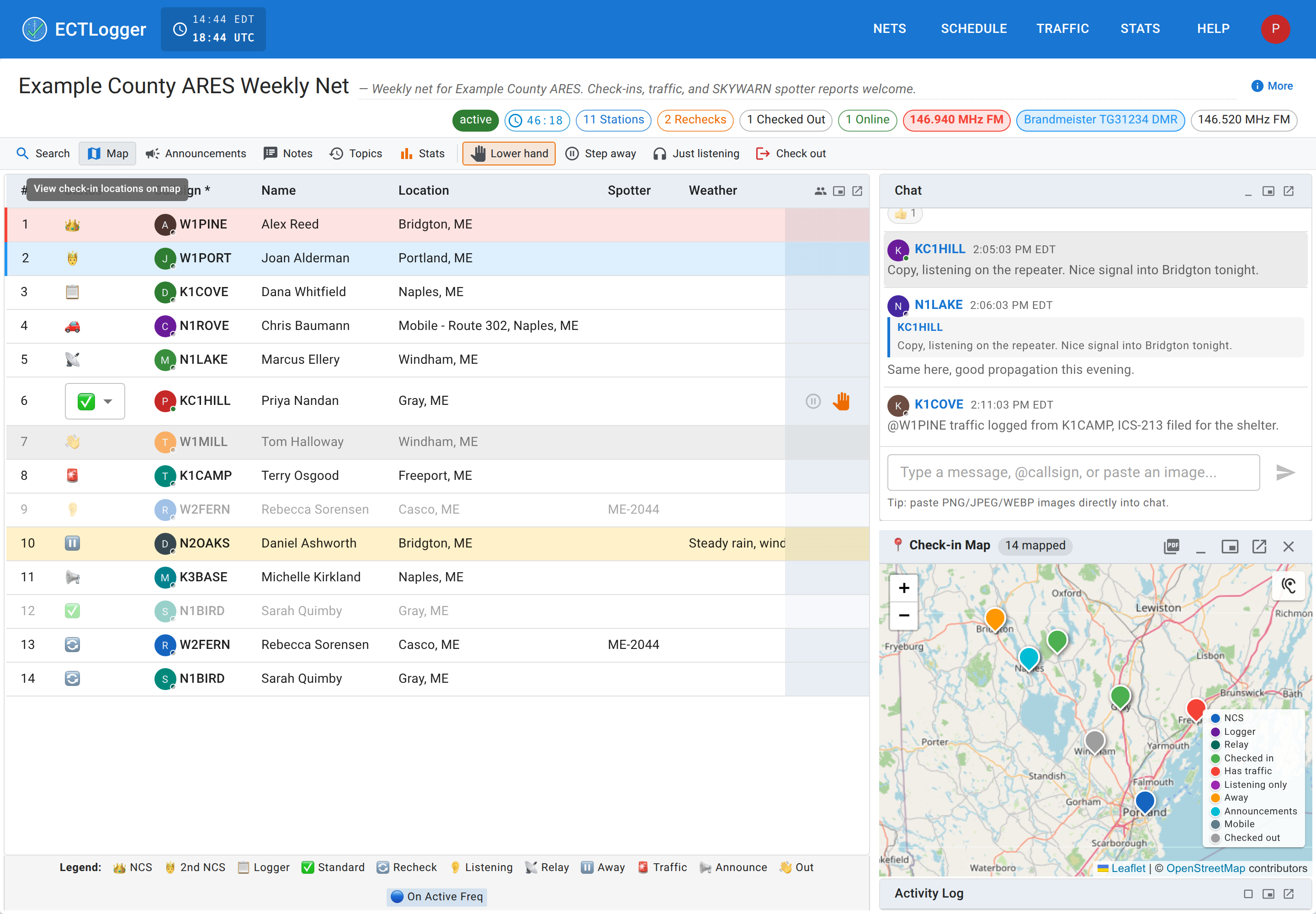
Your location and the map
The Location field on a check-in is free text, but ECTLogger tries to understand it well enough to put a pin on a map. It’s worth knowing what it can parse, because the map is only as good as what got typed into that field.
What the Location field understands
Type any of these into Location (at check-in, or as your default location) and the map can generally place it:
- A place name — “Portland, ME,” a town, a landmark. This gets geocoded against an address lookup service, which takes a moment and needs the location to actually resolve to somewhere real; a vague or made-up place won’t plot.
- GPS coordinates — decimal degrees (
43.6591, -70.2568) or degrees/minutes/seconds (43°39'33"N 70°15'24"W). - Maidenhead grid square — the format amateur radio already uses for propagation reporting (
FN43pp). Understood down to the sub-square if you give it one. - UTM — Universal Transverse Mercator (
19T 348123 4834567). - MGRS — Military Grid Reference System, the format most ARES/served-agency partners already use on paper maps (
19TCH4812334567).
Any of these works equally well. Which one to use is really “whichever one you or the people relying on your report already think in”. A SKYWARN spotter typically has a grid square memorized, a served agency partner coordinating off a paper map is probably giving you MGRS, and a phone’s own GPS app usually hands you decimal coordinates. Pick whichever is fastest and most exact for you in the moment; the map treats all of them the same once parsed. Full format details live in the location formats reference.
Auto-filling it instead of typing it
Two settings, both in your profile, can save you from typing a location every time:
- Default Location fills in whatever you set, every time, until you change it or override it in the moment.
- Location awareness asks your browser for GPS permission and keeps a live Maidenhead grid square, shown in the navbar and used to auto-fill Location on check-in instead of your static default. It only updates while the setting is on and your browser has actually granted permission. There’s a Clear GPS location button in Settings if you want to drop the stored value and stop using it without turning location awareness off entirely.
Either way, whatever auto-fills is still just text in the field before you submit, so edit it if it’s wrong.
What the map actually shows
Every net with at least one parseable location on a check-in has a live map, and the same map data drives the net’s report and its statistics page, with one pipeline behind all three, so a station isn’t plotted on one and missing from another. A few things that surprise people:
- Checked-out stations are still plotted. The map is a record of who took part in the net, not a live “who’s still on frequency” indicator, so someone who checked in, participated, and checked out an hour ago stays on the map.
- There’s no cap on how many stations get mapped. Every check-in with a resolvable location is geocoded and plotted, even on a busy net.
- Markers are colored by role and status — NCS, Logger, Relay, and each station status get their own color, with a legend on the map itself. If a station’s color looks off, check its actual role and status in the check-in list; the legend is the same vocabulary as Status, rechecks, and checking out, not an invented set of map-only categories.